|
|
The Christmas Island gifts you one of the best scenic pleasures of the world. With palm trees swooning to cool breezes by the sun-kissed beaches, this is the place to soothe your fatigued nerves. The Christmas Island is also famous for bird watching as diverse range of bird species nest here, the endemic Christmas Island Bobby and Frigatebird being the most special one. The annual red crab mass migration is another unforgettable sight of the islands with about 100 million of the species covering the whole beach in wet seasons. Over the years, the horrid results of commercialisation and modernism have failed to disturb the ecological balance of the Christmas Island. With 65% of its total area now declared as National Park, this island remains a hub for scientists and biologists who remain hooked to the forest areas in search of best-kept secrets of the nature.
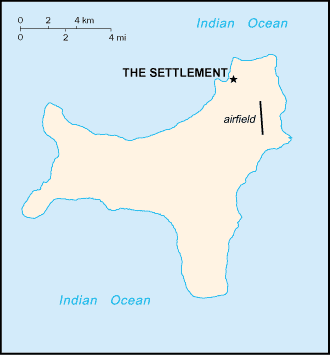
Officially addressed as the Territory of Christmas Island, this single island entity is situated in the Indian Ocean, 2360 km northwest of Perth in Western Australia and 500 km south of Jakarta, Indonesia. Following geo-political terms, the Christmas Island is recognised as part of Oceania continent and non self-governing Territory of Australia.
|
|