|
|
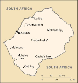
Lesotho lures in travellers from all parts of the globe with beautiful unspoilt scenery and plenty of wildlife. The country and its endearing people showcase the best of African traditions and British colonial remains that contribute to a certain old world charm in the ambience. It would not be an abstract idea to state that the residents of Lesotho are always on a high as over 80% of the country terrain lies above 1,800 m. In fact, it is the only country on earth that is entirely situated at an elevation above 1,000 metres. Lesotho also boasts of the reputation of being an independent nation with a geographical status of enclave. It is surrounded by the Republic of South Africa by all sides.
Lesotho meaning "the land of the people who speak Sotho" was previously known as Basutoland. Britain was the first country to recognise Lesotho as a separate political identity on 13 December 1843 and established the British Protectorate Basutoland a decade later. It was annexed to Cape Colony in 1871, but in 1884 it was restored to direct control by the Crown. The colony of Basutoland became the independent nation of Lesotho on Oct. 4, 1966, with King Moshoeshoe II as sovereign. |
|