|
|
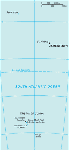
Saint Helena is an informal, remote, rustic and comfortable hideaway that houses some of the best collection of secluded beaches. However, this small island is home to one of the greatest episodes of world history; Saint Helena has been the place of exile of Napoleon Bonaparte from 1815 till his death in 1821. Located off the southwest coast of the mainland of African continent, this island rests over the South Atlantic Ocean. It is a conglomeration of three islands of Ascension Island, Tristan da Cunha and the biggest one of its namesake. Apart from these three major ones, Saint Helena also includes several uninhabited tiny satellite islands and rocks within its territories. The landscape is mostly volcanic, rugged and wild with little scope for human inhabitation.
Saint Helena is presently recognised as an overseas territory of the United Kingdom. It was first discovered in 1502 by João da Nova, a Portuguese navigator but human settlement took place more than a century later with Dutch people arriving here. The East India Company took over Saint Helena in 1659 and it was brought under the direct government of the Crown after April 22, 1834. It was initially used as stopover junction between sea routes to Europe and India. The Ascension Island nestled a large airbase for United States during World War II. |
|