|
|
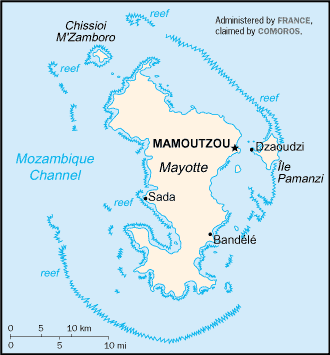
Mayotte has one of the highest rates of repeat visitors and continues to draw people back over and over again with its enjoyable and exciting venues. The landscape is home to an outlandish assortment of wildlife and the surrounding coral reefs construct surreal underwater sculptures. Mayotte is a small island destination over the Indian Ocean and is located at the northern end of the Mozambique Channel. It is group of handful islands that are part of the Comoros Archipelago, Also referred to as Mahoré, following the name of the largest island, Mayotte is 39 km long and 22 km wide, and its highest points are between 500 and 600 meters above sea level. The islands are interconnected with causeways.
France gained colonial control over Mayotte in 1843. It is the most populous of the four Comoros Islands in the Indian Ocean off Mozambique in Africa. Mayotte chose to remain a French dependency rather than join the other Comoran islands in declaring independence in 1975. Comoros laid claim to Mayotte shortly after independence and continues to do so. In July 2000, 70% of voters opted to accept greater autonomy but remain a part of France. Today it is recognised an overseas collectivity of France. |
|