|
|
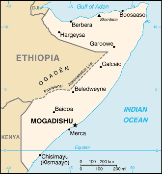
Somalia forms the sharp and pointed edges of the Horn of Africa. Whether you’d like an adventure holiday or just prefer to relax and get away from it all, it’s all waiting here for you in Somalia, the land of smiles. Situated on the horn of East Africa, Somalia enjoys a vast coastline by the Indian Ocean. However, it doesn’t have natural harbours because of inshore coral reefs. The northern region is mountainous with plateaus ranging from 3,000 to 7,000 ft. To the northeast there is an extremely dry dissected plateau that reaches a maximum height of 8,250 ft. South and west of this region, extending to the ShebeliRiver, lies a plateau whose maximum elevation is 2,250 ft. The region between the Juba and Shebeli rivers is low agricultural land, and the area that extends southwest of the Juba River to the Kenyan border is low pasture land.
A flourishing Arab and Persian trading post in the 7th to the 10th century, Somalia housed several nomadic tribes. The reigns of the Turks and the Sultans of Zanzibar spread over the country in 16th century. The regions of present day Somalia witnessed many foreign invasions and by 1920, a British and an Italian protectorate occupied what is now Somalia. By 1960, Britain and Italy granted independence to their respective sectors, enabling the two to join as the Republic of Somalia on July 1, 1960.
|
|